
Amazingly enough only one of these aerial photographs has ever appeared on this website and that is the one on the Home page; unfortunately you are not given much time to look at it in any detail as after about 6 seconds or so it changes to another image and the opportunity to zoom in is not available.
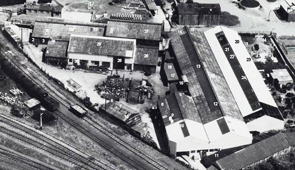
The Company in mid 1947 commissioned Aerofilms (as it was back then) to take these images of the works and the four views below are, in order, taken from the North, South, East and West and were photographed on the 22nd June 1947 (the original hi-res aerial photos still exist, see note below).
There is a terrific amount of detail to be seen and there are even one or two buildings that exist today, July 2020.
Looking at the first image, starting in the bottom left hand corner, can be seen the main railway line to Newton Abbot & Plymouth. The yard to the right of the twin tracks is the Exeter City Council Depot and is still serving that purpose today. The road leading to the top of the image is Exton Road and the present day Civic Amenities facility is at the top left of the image. The area of allotments with the house in the middle has long gone, it appears briefly in the 1935 Film. Below the allotments are the Foundry Buildings in an ‘L’ shape, the foundry had recently been extended and the works are almost finished. Towards the middle bottom of the image is the Basin Branch line that passed under the Main Line to the Canal Basin and the Gas Works. Close inspection and you will see the Tar Tanker Wagons on the siding that served King’s Asphalt who, at the time of this image, occupied the building with the long curved roof, it is still there to this day and is now occupied by South West Crane Hire.
The first two tracks to the right of the building merge into one and head off through Marsh Barton to Ide and Longdown on what was known as the Teign Valley Line. There are sidings off to the old Cattle Market on the upper right hand edge of the image and to the Alphington Road Goods Yard bottom right hand corner. The road that disappears off the bottom of the image over an unguarded level crossing is Tan Lane and it too passes under the Main Line, those of you who are familiar with the Matford Park & Ride Service should be recall the service passes through the low and narrow bridge on its way to Haven Road and the City Centre. You can make out the closed gates to the Council Yard and just above on the left of the road is the Council Weighbridge. The entrance to the foundry site is just to the right of the Council Yard Gates. Parallel to Exton road and on the right side of the road that appears white along some of its length is a footpath which before the foundry was built crossed the site diagonally and had to be re-routed as seen in the image. It makes a 90 degree turn to the right and passes between the allotments and the foundry buildings and on into the Marsh Barton estate. It is still there today.
Having (hopefully) got your bearings we now move on to a view from the South.
Most noticeable is the almost finished work on the foundry extension. Almost central and towards the top of the image is a Railway Water Tower. The road to the left with the almost completed semi detached house is Woodville Road. The railway layout can more easily be seen. The uppermost track halfway up the left hand side of the image leads to the Cattle Market sidings – back then even cattle travelled by rail! At the time of this image the rail network in this area was controlled by the signal box seen adjacent to the Main Line in the right hand top corner. You can see a footbridge serving it from the left of the building.
It may be of interest to note that the day these images were taken, 22nd June 1947, was a Sunday. The next image is taken from the East.
The two storied building parallel to the footpath in the centre of the image had the Works Offices on the first floor. I have just noticed that the entrance to the Foundry Site has the entrance gates in the closed position. On the Tan Lane Foundry page there is a colour photo of the bollard that is immediately adjacent to the left hand pillar of the gates – practically the only object that was effectively part of the complex then and that still exists today. The circular object in the Council Yard is a Wartime construction and is actually an Emergency Water Supply.
The last image is taken from the West and is perhaps able to give the clearest layout of the Foundry buildings – it may be useful to view the original Plans and Drawings (Site-plan Floor-plan Elevation-plan) but like most plans, what turned out in reality was different and I have already mentioned that the light coloured roofs indicate extensions that were added to what was originally constructed in 1939.
The image is slightly different from the other two as it is already slightly enlarged from the original. The entrance to the site off of Tan Lane over the ungated crossing is on the left hand of the image two thirds the way up. The Railway truck that looks as if it is loaded up with something and is isolated on the tracks is immediately adjacent to a set of double wooden gates that allows access to the foundry site. On the Gears and Wheels page one can see how this access was on occasions used.

Here is the Key to the numbers shown on the image.
|
|
NOTE:- Not all this information is totally accurate as over the thirty two years up to the closure of the foundry there were obviously some tweaking and alteration to the layout and positioning of equipment.
The following image, which is unfortunately not of comparable quality to those above, was taken on the 30th September 1945 and shows the Foundry site twenty one months prior to the images above (Image made from the combination of 2 aerial photographs courtesy the National Monuments Record). The 30th September 1945 was also a Sunday. The top of this image is approximately North.
Note: The original high resolution photographs taken by Aerofilms on 22nd June 1947 still exist, now in English Heritage’s collection, and can be viewed online at Britain from Above (britainfromabove.org.uk). There are actually nine views, each allowing you to zoom in and view the Tan Lane site and its surroundings in extraordinary detail - look for EAW007801 - EAW007809.
It would be good if anyone with any images of the works, other than those displayed on this website, who would be happy to share them could contact me – see the About Me page.
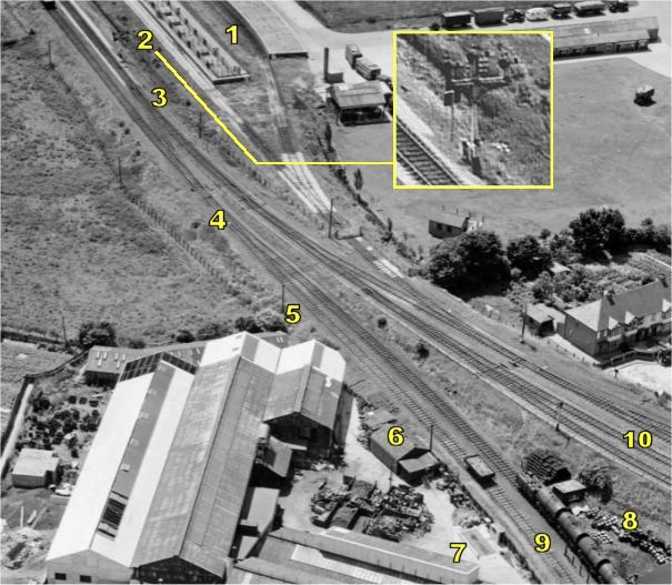
Ever since this website was created in 2009 I have been searching for additional images of the foundry and in particular those taken at ground level. In May 2021 Colin Burges (www.teignrail.co.uk) notified me of the existence of colour film from 1958 which does show two short sequences of film taken looking down the Basin Branch with King’s Asphalt on the left and Garton & King’s foundry on the right. Although in colour the film is not the best quality. The annotated picture below shows the main items visible in the video clip extracted from this film.
 |
KEY 1. Cattle Market branch 2. Signals - train is waiting here at start of clip 3. The points here can be seen in front of the engine 4. These points can be seen in the first view down the Canal branch 5. End of Warehouse and end of Foundry block - the first glimpse of G & K 6. The Garage against the railway embankment 7. The Machine Shop block finally comes into view 8. Kings Asphalt yard, red buildings are seen beyond 9. The Canal Branch 10. to the Main Line and St David’s Station |
At the start of the video the train is stopped at the set of signals some distance before the mainline (2 at the top of this image). The signal changes and there is a brief glimpse of the curved roofed red coloured building that is Kings Asphalt’s premises (8) seen just to left of the signal post. The layout of the tracks in this immediate area can be seen in the image above. As the train pulls away along a left hand curve the cameraman moves to the offside of the carriage and there are two short sequences of film showing the point (3) where the Basin Branch (9) starts. The siding to King’s Asphalt can also be seen. Garton & King’s premises are on the right of the tracks and the first view is of the western end of the foundry complex (5), then the garage (6) and a glimpse of the end of the machine shop (7). The final view is of Kings Asphalt and the Canal Branch (9) heading off towards the bridge under the Main Line and into the Canal Basin area.
The full 22 minute video showing the 1958 journey from Newton Abbot to Exeter and from which this clip was extracted can be seen here.
Updated July 2021
Top of Page
See also:
Tan Lane Foundry — Workplaces
Wheels & Gears
Sitemap / Contents